# leaflet.locatecontrol
> A useful control to geolocate the user with many options. Used by osm.org and mapbox among many others.
Latest version **0.90.1** (published 2026-08-12) · MIT license · 0 weekly downloads
## Install
```sh
npm install leaflet.locatecontrol
pnpm add leaflet.locatecontrol
yarn add leaflet.locatecontrol
bun add leaflet.locatecontrol
```
## Health
**Score 70/100 (B)** — status: active.
Positive: has types; esm support; no vulnerabilities; recently updated; high maintenance score; high quality score.
Warnings: low downloads; pre 1.0.
## Facts
| | |
|---|---|
| Version | 0.90.1 |
| Published | 2026-08-12 |
| First published | 2014-10-28 |
| Weekly downloads | 0 |
| License | MIT |
| TypeScript types | bundled |
| Module format | ESM + CommonJS |
| Dependencies | 0 |
| Unpacked size | 190.3 KB |
| Known vulnerabilities | 0 |
| Install scripts | no |
| GitHub stars | 874 |
| Author | Dominik Moritz |
| Maintainers | domoritz, kristjan.esperanto |
| Keywords | leaflet, locate, plugin |
## Links
- npm: https://www.npmjs.com/package/leaflet.locatecontrol
- Repository: https://github.com/domoritz/leaflet-locatecontrol
- Homepage: https://domoritz.github.io/leaflet-locatecontrol/
- Issues: https://github.com/domoritz/leaflet-locatecontrol/issues
- npm.io page: https://npm.io/package/leaflet.locatecontrol
## Recent versions
- 0.90.1 (latest) — 2026-08-12
- 0.90.0 — 2026-05-06
- 0.89.1 — 2026-05-02
- 0.89.0 — 2026-03-08
- 0.88.0 — 2026-02-11
- 0.87.0 — 2026-01-28
- 0.86.0 — 2026-01-11
- 0.85.1 — 2025-09-08
- 0.85.0 — 2025-09-08
- 0.84.2 — 2025-04-24
- 0.84.1 — 2025-04-01
- 0.83.1 — 2025-01-07
- 0.83.0 — 2024-12-29
- 0.82.0 — 2024-10-29
- 0.81.1 — 2024-05-24
- … 56 more at https://npm.io/package/leaflet.locatecontrol/versions
## README
# Leaflet.Locate
[](https://badge.fury.io/js/leaflet.locatecontrol)
[](https://www.jsdelivr.com/package/npm/leaflet.locatecontrol)
A useful control to geolocate the user with many options. Official [Leaflet](https://leafletjs.com/plugins.html#geolocation) and [MapBox plugin](https://www.mapbox.com/mapbox.js/example/v1.0.0/leaflet-locatecontrol/).
Tested with [Leaflet](https://leafletjs.com/) 1.9.x and 2.x and [Mapbox.js](https://docs.mapbox.com/mapbox.js/) 3.3.1 in Firefox, Chrome and Safari.
Please check for [breaking changes in the changelog](https://github.com/domoritz/leaflet-locatecontrol/blob/gh-pages/CHANGELOG.md).
## Demo
Check out the [demo page](https://domoritz.github.io/leaflet-locatecontrol/) with three different examples (Leaflet UMD, Leaflet ESM, Mapbox UMD).
## Basic Usage
### Set up
1. Get the JavaScript and CSS files
2. Include the files in your project
3. Initialize the plugin
#### Get the JavaScript and CSS files
**For production:**
The best way to get the plugin is via [npm](https://www.npmjs.org/):
```bash
npm install leaflet.locatecontrol
```
Alternatively, you can use the [JsDelivr CDN](https://www.jsdelivr.com/projects/leaflet.locatecontrol) (see instructions below) or [download the files from this repository](https://github.com/domoritz/leaflet-locatecontrol/archive/gh-pages.zip).
**For development:**
Clone the repository to work with the source code:
```bash
git clone https://github.com/domoritz/leaflet-locatecontrol
```
The source files are in `src/` and the built distribution files are in `dist/`.
#### Include the JavaScript and CSS files in your project
##### With CDN
In this example, we are loading the [files from the JsDelivr CDN](https://www.jsdelivr.com/package/npm/leaflet.locatecontrol?path=dist). In the URLs below, replace `[VERSION]` with the latest release number or remove `@[VERSION]` to always use the latest version.
```html
```
##### With `npm`
```ts
import "leaflet.locatecontrol"; // Import plugin
import "leaflet.locatecontrol/dist/L.Control.Locate.min.css"; // Import styles
import L from "leaflet"; // Import L from leaflet to start using the plugin
```
If you are using a bundler or esm, use
```ts
import { LocateControl } from "leaflet.locatecontrol";
import "leaflet.locatecontrol/dist/L.Control.Locate.min.css";
```
Then use `new LocateControl()` instead of `L.control.locate()`.
#### Add the following snippet to your map initialization
This snippet adds the control to the map. You can also pass a configuration.
```js
L.control.locate().addTo(map);
```
### Possible options
The locate control inherits options from [Leaflet Controls](https://leafletjs.com/reference.html#control).
To customize the control, pass an object with your custom options to the locate control.
```js
L.control.locate(OPTIONS).addTo(map);
```
Possible options are listed in the following table. More details are [in the code](https://github.com/domoritz/leaflet-locatecontrol/blob/gh-pages/src/L.Control.Locate.js#L118).
| Option | Type | Description | Default |
|------------|-----------|-------------------|----------|
| `position` | `string` | Position of the control | `topleft` |
| `layer` | [`Layer`](https://leafletjs.com/reference.html#layer) | The layer that the user's location should be drawn on. | a new layer |
| `setView` | `boolean` or `string` | Set the map view (zoom and pan) to the user's location as it updates. Options are `false`, `'once'`, `'always'`, `'untilPan'`, or `'untilPanOrZoom'` | `'untilPanOrZoom'` |
| `flyTo` | `boolean` | Smooth pan and zoom to the location of the marker. | `false` |
| `keepCurrentZoomLevel` | `boolean` or `Array` | Only pan when setting the view. Set to `true` to always keep the current zoom, or provide a zoom range like `[13, 18]` to only keep the zoom when it's within that range. Outside the range, the map will zoom normally. | `false` |
| `initialZoomLevel` | `false` or `integer` | After activating the plugin by clicking on the icon, zoom to the selected zoom level, even when keepCurrentZoomLevel is true. Set to `false` to disable this feature. | `false` |
| `clickBehavior` | `object` | What to do when the user clicks on the control. Has three options `inView`, `inViewNotFollowing` and `outOfView`. Possible values are `stop` and `setView`, or the name of a behaviour to inherit from. | `{inView: 'stop', outOfView: 'setView', inViewNotFollowing: 'inView'}` |
| `returnToPrevBounds` | `boolean` | If set, save the map bounds just before centering to the user's location. When control is disabled, set the view back to the bounds that were saved. | `false` |
| `cacheLocation` | `boolean` | Keep a cache of the location after the user deactivates the control. If set to false, the user has to wait until the locate API returns a new location before they see where they are again. | `true` |
| `showCompass` | `boolean` | Show the compass bearing on top of the location marker | `true` |
| `compassAccuracyThreshold` | `number` or `false` | Maximum allowed iOS compass accuracy in degrees (`webkitCompassAccuracy`) for displaying the compass. `-1` (uncalibrated) is always rejected. Set to `false` to always show the compass when heading data is available. | `45` |
| `drawCircle` | `boolean` | If set, a circle that shows the location accuracy is drawn. | `true` |
| `drawMarker` | `boolean` | If set, the marker at the users' location is drawn. | `true` |
| `markerClass` | `class` | The class to be used to create the marker. | `LocationMarker` |
| `compassClass` | `class` | The class to be used to create the compass marker. | `CompassMarker` |
| `circleStyle` | [`Path options`](https://leafletjs.com/reference.html#path) | Accuracy circle style properties. | see code |
| `markerStyle` | [`Path options`](https://leafletjs.com/reference.html#path) | Inner marker style properties. Only works if your marker class supports `setStyle`. | see code |
| `compassStyle` | [`Path options`](https://leafletjs.com/reference.html#path) | Triangle compass heading marker style properties. Only works if your marker class supports `setStyle`. | see code |
| `followCircleStyle` | [`Path options`](https://leafletjs.com/reference.html#path) | Changes to the accuracy circle while following. Only need to provide changes. | `{}` |
| `followMarkerStyle` | [`Path options`](https://leafletjs.com/reference.html#path) | Changes to the inner marker while following. Only need to provide changes. | `{}` |
| `followCompassStyle` | [`Path options`](https://leafletjs.com/reference.html#path) | Changes to the compass marker while following. Only need to provide changes. | `{}` |
| `icon` | `string` | The CSS class for the icon. | `leaflet-control-locate-location-arrow` |
| `iconLoading` | `string` | The CSS class for the icon while loading. | `leaflet-control-locate-spinner` |
| `iconElementTag` | `string` | The element to be created for icons. | `span` |
| `textElementTag` | `string` | The element to be created for the text. | `small` |
| `circlePadding` | `array` | Padding around the accuracy circle. | `[0, 0]` |
| `createButtonCallback` | `function` | This callback can be used in case you would like to override button creation behavior. | see code |
| `getLocationBounds` | `function` | This callback can be used to override the viewport tracking behavior. | see code |
| `onLocationError` | `function` | Called on location errors. Receives the error and the control instance. | see code |
| `metric` | `boolean` | Use metric units. | `true` |
| `onLocationOutsideMapBounds` | `function` | Called when the user's location is outside the bounds set on the map. Called repeatedly when the user's location changes. | see code |
| `showPopup` | `boolean` | Display a pop-up when the user clicks on the inner marker. | `true` |
| `strings` | `object` | Strings used in the control. Options are `title`, `text`, `metersUnit`, `feetUnit`, `popup` and `outsideMapBoundsMsg` | see code |
| `strings.popup` | `string` or `function` | The string shown as popup. May contain the placeholders `{distance}`, `{unit}`, `{lat}`, `{lng}`, `{altitude}`, `{speed}` (in m/s), and `{heading}` (in degrees). If this option is specified as function, it will be executed with a single parameter `{distance, unit, lat, lng, altitude, speed, heading}` and expected to return a string. | see code |
| `locateOptions` | [`Locate options`](https://leafletjs.com/reference.html#locate-options) | The default options passed to Leaflet's locate method. | see code |
For example, to customize the position and the title, you could write
```js
let lc = L.control
.locate({
position: "topright",
strings: {
title: "Show me where I am, yo!"
}
})
.addTo(map);
```
To add text next to the location icon:
```js
let lc = L.control
.locate({
strings: {
title: "Show me where I am, yo!",
text: "Locate me"
}
})
.addTo(map);
```
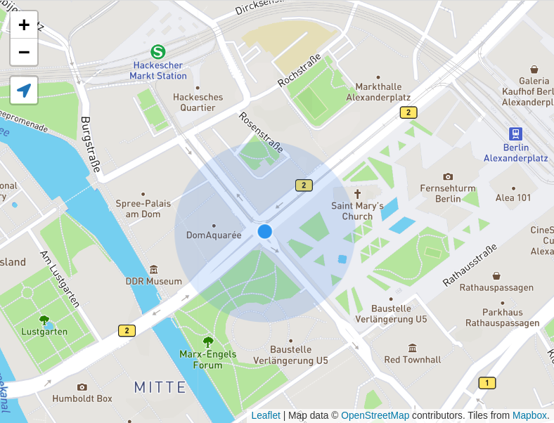
## Screenshot
## Users
Sites that use this locate control:
- [OpenStreetMap](https://www.openstreetmap.org/) on the start page
- [MapBox](https://www.mapbox.com/mapbox.js/example/v1.0.0/leaflet-locatecontrol/)
- [wheelmap.org](https://wheelmap.org/)
- [OpenMensa](https://openmensa.org/)
- [Maps Marker Pro](https://www.mapsmarker.com) (WordPress plugin)
- [Bikemap](https://jackdougherty.github.io/bikemapcode/)
- [MyRoutes](https://myroutes.io/)
- [NearbyWiki](https://en.nearbywiki.org/)
- ...
## Advanced Usage
### Methods
You can call `start()` or `stop()` on the locate control object to set the location on page load for example.
```js
// create control and add to map
let lc = L.control.locate().addTo(map);
// request location update and set location
lc.start();
```
You can keep the plugin active but stop following using `lc.stopFollowing()`.
### Events
You can leverage the native Leaflet events `locationfound` and `locationerror` to handle when geolocation is successful or produces an error. You can find out more about these events in the [Leaflet documentation](https://leafletjs.com/examples/mobile/#geolocation). Note that the control's `onLocationError` callback (which shows a browser `alert()` by default) fires independently of the `locationerror` event — override it to suppress the alert.
Additionally, the locate control fires the following events on the map object:
| Event | Description |
| --------------------- | --------------------------------------------------------------------------------------------------------------- |
| `locateactivate` | Fired when the control is activated |
| `locatedeactivate` | Fired when the control is deactivated |
| `locatelocationfound` | Fired when a location is found (includes `latlng`, `accuracy`, `bounds`, `control`, and other geolocation data) |
| `locationtimeout` | Fired when geolocation timeouts occur in watch mode |
The `locatelocationfound` event is particularly useful when you need to react to location updates with access to the control instance. For example, to get the location once and then stop:
```js
map.on("locatelocationfound", function (e) {
console.log("Location found:", e.latlng);
console.log("Accuracy:", e.accuracy, "meters");
e.control.stop(); // Stop after first location ("one-shot" behavior)
});
```
The `locationtimeout` event is useful when geolocation timeouts occur in watch mode. This is useful for providing custom feedback to users when location acquisition takes longer than expected:
```js
map.on("locationtimeout", function (e) {
console.log("Location timeout count:", e.count);
// Provide custom feedback or retry logic
});
```
Note: When `watch: true` (the default), timeout errors don't stop the location tracking - the browser will automatically retry. After 3 consecutive timeouts, the control displays a visual indicator (orange spinner) to inform users that location acquisition is taking longer than usual.
### Extending
To customize the behavior of the plugin, use L.extend to override `start`, `stop`, `_drawMarker` and/or `_removeMarker`. Please be aware that functions may change and customizations become incompatible.
```js
L.Control.MyLocate = L.Control.Locate.extend({
_drawMarker: function () {
// override to customize the marker
}
});
let lc = new L.Control.MyLocate();
```
### FAQ
#### How do I set the maximum zoom level?
Set the `maxZoom` in `locateOptions` (only applies when `keepCurrentZoomLevel` is `false` or when the current zoom is outside a specified range).
```js
map.addControl(
L.control.locate({
locateOptions: {
maxZoom: 10
}
})
);
```
You can also use `keepCurrentZoomLevel: [13, 18]` to only keep zoom when it's between levels 13-18, but zoom normally outside that range:
```js
map.addControl(
L.control.locate({
keepCurrentZoomLevel: [13, 18],
locateOptions: {
maxZoom: 16
}
})
);
```
#### How do I enable high accuracy?
To enable [high accuracy (GPS) mode](https://leafletjs.com/reference.html#locate-options-enablehighaccuracy), set the `enableHighAccuracy` in `locateOptions`.
```js
map.addControl(
L.control.locate({
locateOptions: {
enableHighAccuracy: true
}
})
);
```
#### Safari does not work with Leaflet 1.7.1
This is a bug in Leaflet. Disable tap to fix it for now. See [this issue](https://github.com/Leaflet/Leaflet/issues/7255) for details.
```js
let map = new L.Map('map', {
tap: false,
...
});
```
## Developers
Run the demo locally with `npm start` and then open [http://localhost:9000](http://localhost:9000).
The development server is a native Node.js script (`scripts/server.js`) that serves the project on port 9000. It does not require any external dependencies. Note that modern browsers treat `localhost` as a secure context, so HTTPS is not required for the Geolocation API to work.
To generate the minified JS and CSS files, run `npm run build`.
## Prettify and linting
Before a Pull Request please check the code style.
Run `npm run lint` to check if there are code style or linting issues.
Run `npm run lint:fix` to automatically fix style and linting issues.
## Making a release (only core developer)
1. Update `CHANGELOG.md` with the changes for the new version and commit: `git commit -am "chore: update changelog"`
2. Run `npm run bump:minor` or `npm run bump:patch` (automatically bumps the version in `package.json`, runs lint, tests, and build, then stages the `dist/` files)
3. Review what will be released: `git log $(git describe --tags --abbrev=0 HEAD^)..HEAD --oneline`
4. `git push && git push --tags` to push the new version to GitHub.
5. `npm login` (if not already logged in)
6. `npm publish` to publish the new version to npm.
### Terms
- **active**: After we called `map.locate()` and before `map.stopLocate()`. Any time, the map can fire the `locationfound` or `locationerror` events.
- **following**: Following refers to whether the map zooms and pans automatically when a new location is found.
## Thanks
To all [contributors](https://github.com/domoritz/leaflet-locatecontrol/contributors) and issue reporters.
## License
This project is licensed under the MIT License - see the [LICENSE.md](LICENSE.md) file for details.
## Attributions
SVG icons from [Font Awesome v5.15.4](https://github.com/FortAwesome/Font-Awesome/releases/tag/5.15.4): [Creative Commons Attribution 4.0](https://fontawesome.com/license/free)
---
_Source: https://npm.io/package/leaflet.locatecontrol · Machine-readable twin of the npm.io package page. Health data is recomputed on every publish._
 Leaflet.Locate
[](https://badge.fury.io/js/leaflet.locatecontrol)
[](https://www.jsdelivr.com/package/npm/leaflet.locatecontrol)
A useful control to geolocate the user with many options. Official [Leaflet](https://leafletjs.com/plugins.html#geolocation) and [MapBox plugin](https://www.mapbox.com/mapbox.js/example/v1.0.0/leaflet-locatecontrol/).
Tested with [Leaflet](https://leafletjs.com/) 1.9.x and 2.x and [Mapbox.js](https://docs.mapbox.com/mapbox.js/) 3.3.1 in Firefox, Chrome and Safari.
Please check for [breaking changes in the changelog](https://github.com/domoritz/leaflet-locatecontrol/blob/gh-pages/CHANGELOG.md).
## Demo
Check out the [demo page](https://domoritz.github.io/leaflet-locatecontrol/) with three different examples (Leaflet UMD, Leaflet ESM, Mapbox UMD).
## Basic Usage
### Set up
1. Get the JavaScript and CSS files
2. Include the files in your project
3. Initialize the plugin
#### Get the JavaScript and CSS files
**For production:**
The best way to get the plugin is via [npm](https://www.npmjs.org/):
```bash
npm install leaflet.locatecontrol
```
Alternatively, you can use the [JsDelivr CDN](https://www.jsdelivr.com/projects/leaflet.locatecontrol) (see instructions below) or [download the files from this repository](https://github.com/domoritz/leaflet-locatecontrol/archive/gh-pages.zip).
**For development:**
Clone the repository to work with the source code:
```bash
git clone https://github.com/domoritz/leaflet-locatecontrol
```
The source files are in `src/` and the built distribution files are in `dist/`.
#### Include the JavaScript and CSS files in your project
##### With CDN
In this example, we are loading the [files from the JsDelivr CDN](https://www.jsdelivr.com/package/npm/leaflet.locatecontrol?path=dist). In the URLs below, replace `[VERSION]` with the latest release number or remove `@[VERSION]` to always use the latest version.
```html
```
##### With `npm`
```ts
import "leaflet.locatecontrol"; // Import plugin
import "leaflet.locatecontrol/dist/L.Control.Locate.min.css"; // Import styles
import L from "leaflet"; // Import L from leaflet to start using the plugin
```
If you are using a bundler or esm, use
```ts
import { LocateControl } from "leaflet.locatecontrol";
import "leaflet.locatecontrol/dist/L.Control.Locate.min.css";
```
Then use `new LocateControl()` instead of `L.control.locate()`.
#### Add the following snippet to your map initialization
This snippet adds the control to the map. You can also pass a configuration.
```js
L.control.locate().addTo(map);
```
### Possible options
The locate control inherits options from [Leaflet Controls](https://leafletjs.com/reference.html#control).
To customize the control, pass an object with your custom options to the locate control.
```js
L.control.locate(OPTIONS).addTo(map);
```
Possible options are listed in the following table. More details are [in the code](https://github.com/domoritz/leaflet-locatecontrol/blob/gh-pages/src/L.Control.Locate.js#L118).
| Option | Type | Description | Default |
|------------|-----------|-------------------|----------|
| `position` | `string` | Position of the control | `topleft` |
| `layer` | [`Layer`](https://leafletjs.com/reference.html#layer) | The layer that the user's location should be drawn on. | a new layer |
| `setView` | `boolean` or `string` | Set the map view (zoom and pan) to the user's location as it updates. Options are `false`, `'once'`, `'always'`, `'untilPan'`, or `'untilPanOrZoom'` | `'untilPanOrZoom'` |
| `flyTo` | `boolean` | Smooth pan and zoom to the location of the marker. | `false` |
| `keepCurrentZoomLevel` | `boolean` or `Array` | Only pan when setting the view. Set to `true` to always keep the current zoom, or provide a zoom range like `[13, 18]` to only keep the zoom when it's within that range. Outside the range, the map will zoom normally. | `false` |
| `initialZoomLevel` | `false` or `integer` | After activating the plugin by clicking on the icon, zoom to the selected zoom level, even when keepCurrentZoomLevel is true. Set to `false` to disable this feature. | `false` |
| `clickBehavior` | `object` | What to do when the user clicks on the control. Has three options `inView`, `inViewNotFollowing` and `outOfView`. Possible values are `stop` and `setView`, or the name of a behaviour to inherit from. | `{inView: 'stop', outOfView: 'setView', inViewNotFollowing: 'inView'}` |
| `returnToPrevBounds` | `boolean` | If set, save the map bounds just before centering to the user's location. When control is disabled, set the view back to the bounds that were saved. | `false` |
| `cacheLocation` | `boolean` | Keep a cache of the location after the user deactivates the control. If set to false, the user has to wait until the locate API returns a new location before they see where they are again. | `true` |
| `showCompass` | `boolean` | Show the compass bearing on top of the location marker | `true` |
| `compassAccuracyThreshold` | `number` or `false` | Maximum allowed iOS compass accuracy in degrees (`webkitCompassAccuracy`) for displaying the compass. `-1` (uncalibrated) is always rejected. Set to `false` to always show the compass when heading data is available. | `45` |
| `drawCircle` | `boolean` | If set, a circle that shows the location accuracy is drawn. | `true` |
| `drawMarker` | `boolean` | If set, the marker at the users' location is drawn. | `true` |
| `markerClass` | `class` | The class to be used to create the marker. | `LocationMarker` |
| `compassClass` | `class` | The class to be used to create the compass marker. | `CompassMarker` |
| `circleStyle` | [`Path options`](https://leafletjs.com/reference.html#path) | Accuracy circle style properties. | see code |
| `markerStyle` | [`Path options`](https://leafletjs.com/reference.html#path) | Inner marker style properties. Only works if your marker class supports `setStyle`. | see code |
| `compassStyle` | [`Path options`](https://leafletjs.com/reference.html#path) | Triangle compass heading marker style properties. Only works if your marker class supports `setStyle`. | see code |
| `followCircleStyle` | [`Path options`](https://leafletjs.com/reference.html#path) | Changes to the accuracy circle while following. Only need to provide changes. | `{}` |
| `followMarkerStyle` | [`Path options`](https://leafletjs.com/reference.html#path) | Changes to the inner marker while following. Only need to provide changes. | `{}` |
| `followCompassStyle` | [`Path options`](https://leafletjs.com/reference.html#path) | Changes to the compass marker while following. Only need to provide changes. | `{}` |
| `icon` | `string` | The CSS class for the icon. | `leaflet-control-locate-location-arrow` |
| `iconLoading` | `string` | The CSS class for the icon while loading. | `leaflet-control-locate-spinner` |
| `iconElementTag` | `string` | The element to be created for icons. | `span` |
| `textElementTag` | `string` | The element to be created for the text. | `small` |
| `circlePadding` | `array` | Padding around the accuracy circle. | `[0, 0]` |
| `createButtonCallback` | `function` | This callback can be used in case you would like to override button creation behavior. | see code |
| `getLocationBounds` | `function` | This callback can be used to override the viewport tracking behavior. | see code |
| `onLocationError` | `function` | Called on location errors. Receives the error and the control instance. | see code |
| `metric` | `boolean` | Use metric units. | `true` |
| `onLocationOutsideMapBounds` | `function` | Called when the user's location is outside the bounds set on the map. Called repeatedly when the user's location changes. | see code |
| `showPopup` | `boolean` | Display a pop-up when the user clicks on the inner marker. | `true` |
| `strings` | `object` | Strings used in the control. Options are `title`, `text`, `metersUnit`, `feetUnit`, `popup` and `outsideMapBoundsMsg` | see code |
| `strings.popup` | `string` or `function` | The string shown as popup. May contain the placeholders `{distance}`, `{unit}`, `{lat}`, `{lng}`, `{altitude}`, `{speed}` (in m/s), and `{heading}` (in degrees). If this option is specified as function, it will be executed with a single parameter `{distance, unit, lat, lng, altitude, speed, heading}` and expected to return a string. | see code |
| `locateOptions` | [`Locate options`](https://leafletjs.com/reference.html#locate-options) | The default options passed to Leaflet's locate method. | see code |
For example, to customize the position and the title, you could write
```js
let lc = L.control
.locate({
position: "topright",
strings: {
title: "Show me where I am, yo!"
}
})
.addTo(map);
```
To add text next to the location icon:
```js
let lc = L.control
.locate({
strings: {
title: "Show me where I am, yo!",
text: "Locate me"
}
})
.addTo(map);
```
## Screenshot

## Users
Sites that use this locate control:
- [OpenStreetMap](https://www.openstreetmap.org/) on the start page
- [MapBox](https://www.mapbox.com/mapbox.js/example/v1.0.0/leaflet-locatecontrol/)
- [wheelmap.org](https://wheelmap.org/)
- [OpenMensa](https://openmensa.org/)
- [Maps Marker Pro](https://www.mapsmarker.com) (WordPress plugin)
- [Bikemap](https://jackdougherty.github.io/bikemapcode/)
- [MyRoutes](https://myroutes.io/)
- [NearbyWiki](https://en.nearbywiki.org/)
- ...
## Advanced Usage
### Methods
You can call `start()` or `stop()` on the locate control object to set the location on page load for example.
```js
// create control and add to map
let lc = L.control.locate().addTo(map);
// request location update and set location
lc.start();
```
You can keep the plugin active but stop following using `lc.stopFollowing()`.
### Events
You can leverage the native Leaflet events `locationfound` and `locationerror` to handle when geolocation is successful or produces an error. You can find out more about these events in the [Leaflet documentation](https://leafletjs.com/examples/mobile/#geolocation). Note that the control's `onLocationError` callback (which shows a browser `alert()` by default) fires independently of the `locationerror` event — override it to suppress the alert.
Additionally, the locate control fires the following events on the map object:
| Event | Description |
| --------------------- | --------------------------------------------------------------------------------------------------------------- |
| `locateactivate` | Fired when the control is activated |
| `locatedeactivate` | Fired when the control is deactivated |
| `locatelocationfound` | Fired when a location is found (includes `latlng`, `accuracy`, `bounds`, `control`, and other geolocation data) |
| `locationtimeout` | Fired when geolocation timeouts occur in watch mode |
The `locatelocationfound` event is particularly useful when you need to react to location updates with access to the control instance. For example, to get the location once and then stop:
```js
map.on("locatelocationfound", function (e) {
console.log("Location found:", e.latlng);
console.log("Accuracy:", e.accuracy, "meters");
e.control.stop(); // Stop after first location ("one-shot" behavior)
});
```
The `locationtimeout` event is useful when geolocation timeouts occur in watch mode. This is useful for providing custom feedback to users when location acquisition takes longer than expected:
```js
map.on("locationtimeout", function (e) {
console.log("Location timeout count:", e.count);
// Provide custom feedback or retry logic
});
```
Note: When `watch: true` (the default), timeout errors don't stop the location tracking - the browser will automatically retry. After 3 consecutive timeouts, the control displays a visual indicator (orange spinner) to inform users that location acquisition is taking longer than usual.
### Extending
To customize the behavior of the plugin, use L.extend to override `start`, `stop`, `_drawMarker` and/or `_removeMarker`. Please be aware that functions may change and customizations become incompatible.
```js
L.Control.MyLocate = L.Control.Locate.extend({
_drawMarker: function () {
// override to customize the marker
}
});
let lc = new L.Control.MyLocate();
```
### FAQ
#### How do I set the maximum zoom level?
Set the `maxZoom` in `locateOptions` (only applies when `keepCurrentZoomLevel` is `false` or when the current zoom is outside a specified range).
```js
map.addControl(
L.control.locate({
locateOptions: {
maxZoom: 10
}
})
);
```
You can also use `keepCurrentZoomLevel: [13, 18]` to only keep zoom when it's between levels 13-18, but zoom normally outside that range:
```js
map.addControl(
L.control.locate({
keepCurrentZoomLevel: [13, 18],
locateOptions: {
maxZoom: 16
}
})
);
```
#### How do I enable high accuracy?
To enable [high accuracy (GPS) mode](https://leafletjs.com/reference.html#locate-options-enablehighaccuracy), set the `enableHighAccuracy` in `locateOptions`.
```js
map.addControl(
L.control.locate({
locateOptions: {
enableHighAccuracy: true
}
})
);
```
#### Safari does not work with Leaflet 1.7.1
This is a bug in Leaflet. Disable tap to fix it for now. See [this issue](https://github.com/Leaflet/Leaflet/issues/7255) for details.
```js
let map = new L.Map('map', {
tap: false,
...
});
```
## Developers
Run the demo locally with `npm start` and then open [http://localhost:9000](http://localhost:9000).
The development server is a native Node.js script (`scripts/server.js`) that serves the project on port 9000. It does not require any external dependencies. Note that modern browsers treat `localhost` as a secure context, so HTTPS is not required for the Geolocation API to work.
To generate the minified JS and CSS files, run `npm run build`.
## Prettify and linting
Before a Pull Request please check the code style.
Run `npm run lint` to check if there are code style or linting issues.
Run `npm run lint:fix` to automatically fix style and linting issues.
## Making a release (only core developer)
1. Update `CHANGELOG.md` with the changes for the new version and commit: `git commit -am "chore: update changelog"`
2. Run `npm run bump:minor` or `npm run bump:patch` (automatically bumps the version in `package.json`, runs lint, tests, and build, then stages the `dist/` files)
3. Review what will be released: `git log $(git describe --tags --abbrev=0 HEAD^)..HEAD --oneline`
4. `git push && git push --tags` to push the new version to GitHub.
5. `npm login` (if not already logged in)
6. `npm publish` to publish the new version to npm.
### Terms
- **active**: After we called `map.locate()` and before `map.stopLocate()`. Any time, the map can fire the `locationfound` or `locationerror` events.
- **following**: Following refers to whether the map zooms and pans automatically when a new location is found.
## Thanks
To all [contributors](https://github.com/domoritz/leaflet-locatecontrol/contributors) and issue reporters.
## License
This project is licensed under the MIT License - see the [LICENSE.md](LICENSE.md) file for details.
## Attributions
SVG icons from [Font Awesome v5.15.4](https://github.com/FortAwesome/Font-Awesome/releases/tag/5.15.4): [Creative Commons Attribution 4.0](https://fontawesome.com/license/free)
---
_Source: https://npm.io/package/leaflet.locatecontrol · Machine-readable twin of the npm.io package page. Health data is recomputed on every publish._
Leaflet.Locate
[](https://badge.fury.io/js/leaflet.locatecontrol)
[](https://www.jsdelivr.com/package/npm/leaflet.locatecontrol)
A useful control to geolocate the user with many options. Official [Leaflet](https://leafletjs.com/plugins.html#geolocation) and [MapBox plugin](https://www.mapbox.com/mapbox.js/example/v1.0.0/leaflet-locatecontrol/).
Tested with [Leaflet](https://leafletjs.com/) 1.9.x and 2.x and [Mapbox.js](https://docs.mapbox.com/mapbox.js/) 3.3.1 in Firefox, Chrome and Safari.
Please check for [breaking changes in the changelog](https://github.com/domoritz/leaflet-locatecontrol/blob/gh-pages/CHANGELOG.md).
## Demo
Check out the [demo page](https://domoritz.github.io/leaflet-locatecontrol/) with three different examples (Leaflet UMD, Leaflet ESM, Mapbox UMD).
## Basic Usage
### Set up
1. Get the JavaScript and CSS files
2. Include the files in your project
3. Initialize the plugin
#### Get the JavaScript and CSS files
**For production:**
The best way to get the plugin is via [npm](https://www.npmjs.org/):
```bash
npm install leaflet.locatecontrol
```
Alternatively, you can use the [JsDelivr CDN](https://www.jsdelivr.com/projects/leaflet.locatecontrol) (see instructions below) or [download the files from this repository](https://github.com/domoritz/leaflet-locatecontrol/archive/gh-pages.zip).
**For development:**
Clone the repository to work with the source code:
```bash
git clone https://github.com/domoritz/leaflet-locatecontrol
```
The source files are in `src/` and the built distribution files are in `dist/`.
#### Include the JavaScript and CSS files in your project
##### With CDN
In this example, we are loading the [files from the JsDelivr CDN](https://www.jsdelivr.com/package/npm/leaflet.locatecontrol?path=dist). In the URLs below, replace `[VERSION]` with the latest release number or remove `@[VERSION]` to always use the latest version.
```html
```
##### With `npm`
```ts
import "leaflet.locatecontrol"; // Import plugin
import "leaflet.locatecontrol/dist/L.Control.Locate.min.css"; // Import styles
import L from "leaflet"; // Import L from leaflet to start using the plugin
```
If you are using a bundler or esm, use
```ts
import { LocateControl } from "leaflet.locatecontrol";
import "leaflet.locatecontrol/dist/L.Control.Locate.min.css";
```
Then use `new LocateControl()` instead of `L.control.locate()`.
#### Add the following snippet to your map initialization
This snippet adds the control to the map. You can also pass a configuration.
```js
L.control.locate().addTo(map);
```
### Possible options
The locate control inherits options from [Leaflet Controls](https://leafletjs.com/reference.html#control).
To customize the control, pass an object with your custom options to the locate control.
```js
L.control.locate(OPTIONS).addTo(map);
```
Possible options are listed in the following table. More details are [in the code](https://github.com/domoritz/leaflet-locatecontrol/blob/gh-pages/src/L.Control.Locate.js#L118).
| Option | Type | Description | Default |
|------------|-----------|-------------------|----------|
| `position` | `string` | Position of the control | `topleft` |
| `layer` | [`Layer`](https://leafletjs.com/reference.html#layer) | The layer that the user's location should be drawn on. | a new layer |
| `setView` | `boolean` or `string` | Set the map view (zoom and pan) to the user's location as it updates. Options are `false`, `'once'`, `'always'`, `'untilPan'`, or `'untilPanOrZoom'` | `'untilPanOrZoom'` |
| `flyTo` | `boolean` | Smooth pan and zoom to the location of the marker. | `false` |
| `keepCurrentZoomLevel` | `boolean` or `Array` | Only pan when setting the view. Set to `true` to always keep the current zoom, or provide a zoom range like `[13, 18]` to only keep the zoom when it's within that range. Outside the range, the map will zoom normally. | `false` |
| `initialZoomLevel` | `false` or `integer` | After activating the plugin by clicking on the icon, zoom to the selected zoom level, even when keepCurrentZoomLevel is true. Set to `false` to disable this feature. | `false` |
| `clickBehavior` | `object` | What to do when the user clicks on the control. Has three options `inView`, `inViewNotFollowing` and `outOfView`. Possible values are `stop` and `setView`, or the name of a behaviour to inherit from. | `{inView: 'stop', outOfView: 'setView', inViewNotFollowing: 'inView'}` |
| `returnToPrevBounds` | `boolean` | If set, save the map bounds just before centering to the user's location. When control is disabled, set the view back to the bounds that were saved. | `false` |
| `cacheLocation` | `boolean` | Keep a cache of the location after the user deactivates the control. If set to false, the user has to wait until the locate API returns a new location before they see where they are again. | `true` |
| `showCompass` | `boolean` | Show the compass bearing on top of the location marker | `true` |
| `compassAccuracyThreshold` | `number` or `false` | Maximum allowed iOS compass accuracy in degrees (`webkitCompassAccuracy`) for displaying the compass. `-1` (uncalibrated) is always rejected. Set to `false` to always show the compass when heading data is available. | `45` |
| `drawCircle` | `boolean` | If set, a circle that shows the location accuracy is drawn. | `true` |
| `drawMarker` | `boolean` | If set, the marker at the users' location is drawn. | `true` |
| `markerClass` | `class` | The class to be used to create the marker. | `LocationMarker` |
| `compassClass` | `class` | The class to be used to create the compass marker. | `CompassMarker` |
| `circleStyle` | [`Path options`](https://leafletjs.com/reference.html#path) | Accuracy circle style properties. | see code |
| `markerStyle` | [`Path options`](https://leafletjs.com/reference.html#path) | Inner marker style properties. Only works if your marker class supports `setStyle`. | see code |
| `compassStyle` | [`Path options`](https://leafletjs.com/reference.html#path) | Triangle compass heading marker style properties. Only works if your marker class supports `setStyle`. | see code |
| `followCircleStyle` | [`Path options`](https://leafletjs.com/reference.html#path) | Changes to the accuracy circle while following. Only need to provide changes. | `{}` |
| `followMarkerStyle` | [`Path options`](https://leafletjs.com/reference.html#path) | Changes to the inner marker while following. Only need to provide changes. | `{}` |
| `followCompassStyle` | [`Path options`](https://leafletjs.com/reference.html#path) | Changes to the compass marker while following. Only need to provide changes. | `{}` |
| `icon` | `string` | The CSS class for the icon. | `leaflet-control-locate-location-arrow` |
| `iconLoading` | `string` | The CSS class for the icon while loading. | `leaflet-control-locate-spinner` |
| `iconElementTag` | `string` | The element to be created for icons. | `span` |
| `textElementTag` | `string` | The element to be created for the text. | `small` |
| `circlePadding` | `array` | Padding around the accuracy circle. | `[0, 0]` |
| `createButtonCallback` | `function` | This callback can be used in case you would like to override button creation behavior. | see code |
| `getLocationBounds` | `function` | This callback can be used to override the viewport tracking behavior. | see code |
| `onLocationError` | `function` | Called on location errors. Receives the error and the control instance. | see code |
| `metric` | `boolean` | Use metric units. | `true` |
| `onLocationOutsideMapBounds` | `function` | Called when the user's location is outside the bounds set on the map. Called repeatedly when the user's location changes. | see code |
| `showPopup` | `boolean` | Display a pop-up when the user clicks on the inner marker. | `true` |
| `strings` | `object` | Strings used in the control. Options are `title`, `text`, `metersUnit`, `feetUnit`, `popup` and `outsideMapBoundsMsg` | see code |
| `strings.popup` | `string` or `function` | The string shown as popup. May contain the placeholders `{distance}`, `{unit}`, `{lat}`, `{lng}`, `{altitude}`, `{speed}` (in m/s), and `{heading}` (in degrees). If this option is specified as function, it will be executed with a single parameter `{distance, unit, lat, lng, altitude, speed, heading}` and expected to return a string. | see code |
| `locateOptions` | [`Locate options`](https://leafletjs.com/reference.html#locate-options) | The default options passed to Leaflet's locate method. | see code |
For example, to customize the position and the title, you could write
```js
let lc = L.control
.locate({
position: "topright",
strings: {
title: "Show me where I am, yo!"
}
})
.addTo(map);
```
To add text next to the location icon:
```js
let lc = L.control
.locate({
strings: {
title: "Show me where I am, yo!",
text: "Locate me"
}
})
.addTo(map);
```
## Screenshot

## Users
Sites that use this locate control:
- [OpenStreetMap](https://www.openstreetmap.org/) on the start page
- [MapBox](https://www.mapbox.com/mapbox.js/example/v1.0.0/leaflet-locatecontrol/)
- [wheelmap.org](https://wheelmap.org/)
- [OpenMensa](https://openmensa.org/)
- [Maps Marker Pro](https://www.mapsmarker.com) (WordPress plugin)
- [Bikemap](https://jackdougherty.github.io/bikemapcode/)
- [MyRoutes](https://myroutes.io/)
- [NearbyWiki](https://en.nearbywiki.org/)
- ...
## Advanced Usage
### Methods
You can call `start()` or `stop()` on the locate control object to set the location on page load for example.
```js
// create control and add to map
let lc = L.control.locate().addTo(map);
// request location update and set location
lc.start();
```
You can keep the plugin active but stop following using `lc.stopFollowing()`.
### Events
You can leverage the native Leaflet events `locationfound` and `locationerror` to handle when geolocation is successful or produces an error. You can find out more about these events in the [Leaflet documentation](https://leafletjs.com/examples/mobile/#geolocation). Note that the control's `onLocationError` callback (which shows a browser `alert()` by default) fires independently of the `locationerror` event — override it to suppress the alert.
Additionally, the locate control fires the following events on the map object:
| Event | Description |
| --------------------- | --------------------------------------------------------------------------------------------------------------- |
| `locateactivate` | Fired when the control is activated |
| `locatedeactivate` | Fired when the control is deactivated |
| `locatelocationfound` | Fired when a location is found (includes `latlng`, `accuracy`, `bounds`, `control`, and other geolocation data) |
| `locationtimeout` | Fired when geolocation timeouts occur in watch mode |
The `locatelocationfound` event is particularly useful when you need to react to location updates with access to the control instance. For example, to get the location once and then stop:
```js
map.on("locatelocationfound", function (e) {
console.log("Location found:", e.latlng);
console.log("Accuracy:", e.accuracy, "meters");
e.control.stop(); // Stop after first location ("one-shot" behavior)
});
```
The `locationtimeout` event is useful when geolocation timeouts occur in watch mode. This is useful for providing custom feedback to users when location acquisition takes longer than expected:
```js
map.on("locationtimeout", function (e) {
console.log("Location timeout count:", e.count);
// Provide custom feedback or retry logic
});
```
Note: When `watch: true` (the default), timeout errors don't stop the location tracking - the browser will automatically retry. After 3 consecutive timeouts, the control displays a visual indicator (orange spinner) to inform users that location acquisition is taking longer than usual.
### Extending
To customize the behavior of the plugin, use L.extend to override `start`, `stop`, `_drawMarker` and/or `_removeMarker`. Please be aware that functions may change and customizations become incompatible.
```js
L.Control.MyLocate = L.Control.Locate.extend({
_drawMarker: function () {
// override to customize the marker
}
});
let lc = new L.Control.MyLocate();
```
### FAQ
#### How do I set the maximum zoom level?
Set the `maxZoom` in `locateOptions` (only applies when `keepCurrentZoomLevel` is `false` or when the current zoom is outside a specified range).
```js
map.addControl(
L.control.locate({
locateOptions: {
maxZoom: 10
}
})
);
```
You can also use `keepCurrentZoomLevel: [13, 18]` to only keep zoom when it's between levels 13-18, but zoom normally outside that range:
```js
map.addControl(
L.control.locate({
keepCurrentZoomLevel: [13, 18],
locateOptions: {
maxZoom: 16
}
})
);
```
#### How do I enable high accuracy?
To enable [high accuracy (GPS) mode](https://leafletjs.com/reference.html#locate-options-enablehighaccuracy), set the `enableHighAccuracy` in `locateOptions`.
```js
map.addControl(
L.control.locate({
locateOptions: {
enableHighAccuracy: true
}
})
);
```
#### Safari does not work with Leaflet 1.7.1
This is a bug in Leaflet. Disable tap to fix it for now. See [this issue](https://github.com/Leaflet/Leaflet/issues/7255) for details.
```js
let map = new L.Map('map', {
tap: false,
...
});
```
## Developers
Run the demo locally with `npm start` and then open [http://localhost:9000](http://localhost:9000).
The development server is a native Node.js script (`scripts/server.js`) that serves the project on port 9000. It does not require any external dependencies. Note that modern browsers treat `localhost` as a secure context, so HTTPS is not required for the Geolocation API to work.
To generate the minified JS and CSS files, run `npm run build`.
## Prettify and linting
Before a Pull Request please check the code style.
Run `npm run lint` to check if there are code style or linting issues.
Run `npm run lint:fix` to automatically fix style and linting issues.
## Making a release (only core developer)
1. Update `CHANGELOG.md` with the changes for the new version and commit: `git commit -am "chore: update changelog"`
2. Run `npm run bump:minor` or `npm run bump:patch` (automatically bumps the version in `package.json`, runs lint, tests, and build, then stages the `dist/` files)
3. Review what will be released: `git log $(git describe --tags --abbrev=0 HEAD^)..HEAD --oneline`
4. `git push && git push --tags` to push the new version to GitHub.
5. `npm login` (if not already logged in)
6. `npm publish` to publish the new version to npm.
### Terms
- **active**: After we called `map.locate()` and before `map.stopLocate()`. Any time, the map can fire the `locationfound` or `locationerror` events.
- **following**: Following refers to whether the map zooms and pans automatically when a new location is found.
## Thanks
To all [contributors](https://github.com/domoritz/leaflet-locatecontrol/contributors) and issue reporters.
## License
This project is licensed under the MIT License - see the [LICENSE.md](LICENSE.md) file for details.
## Attributions
SVG icons from [Font Awesome v5.15.4](https://github.com/FortAwesome/Font-Awesome/releases/tag/5.15.4): [Creative Commons Attribution 4.0](https://fontawesome.com/license/free)
---
_Source: https://npm.io/package/leaflet.locatecontrol · Machine-readable twin of the npm.io package page. Health data is recomputed on every publish._