@websy/tubemap-viz v1.0.0
tubemap-viz
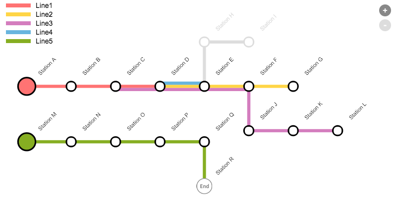
An HTML5 Canvas based visualisation that lets you represent data in the style of a Tube/Metro map.
The map is a work in progress but feel free to use, abuse and contribute. Enjoy.
Example:

Setup
Load the TubeMapViz library into your webpage
<script src='https://rawgit.com/websy85/tubemap-viz/master/dist/tube-map-viz.js'></script>Example Usage
Create an element to use as the map parent
<div id="mapContainer" style="width:800; height:600px;"></div>Create a new instance of TubeMapViz
var myTubeMap = new TubeMapViz();Using the sample data provided, call the render() function to draw the map
myTubeMap.render(myTubeMap.sampleData, document.getElementById("mapContainer"));Data Structure
The data expected by the map is an array of objects structured like this
{
  "name": String, (required)
  "colour": String, //if set overrides the colours property in the map options
  "stations": Array (required) [
    {
      "name": String (required),
      "status": Number, //1 - default || 0 - draws an inactive line either side of the station using the specified 'inactiveColour'
      "distanceToNext": Number, //if set is used to determine the distance between this and the next station. a scale is created using the min and max values.
      "custom": {
        "fill": String, //overrides the station fill colour
        "stroke": String, //overrides the station stroke colour
        "scale": Number, //scales the station by the specified scale
        "image": String, (url) //allows an image to be used to represent the station
        "imageSize": Number, //specifies the diameter of the image used
        "drawLabel": Boolean  //if true then the label for the station is not drawn
      }
    }
  ]
}
Options
When creating a new instance of TubeMapViz a configuration object can be passed in.
var options = {
  fontSize: 14
}
var myTubeMap = new TubeMapViz(options);
Options can also be set after creation
myTubeMap.fontSize = 14;The following is a list of available options
{
  "debug": Boolean, //defaults to false;
  "disableHighlighting": Boolean, //defaults to false. if true stations will not 'popout' on mouseover;
  "padding": Number,  //defaults to 30;
  "stationRadius": Number,  //defaults to 8;
  "lineWidth": Number,  //defaults to 5;
  "lineSpacing": Number,  //defaults to 5;
  "colours": Array, // defaults to ["#ff7373","#ffd546","#d47dbe","#68b5de","#86ae22"].
  "labelLineHeight": Number,  //defaults to 13;
  "labelColour": String,  //defaults to "black";
  "labelWrapThreshold": Number, //defaults to 4 cells. cell size is equal to 2 x stationRadius;
  "fontSize": Number, //defaults to 10;
  "fontFamily": String, //defaults to "Arial";
  "fontWeight": String, //defaults to "Normal";
  "highlightScale": Number, //defaults to 1.3;
  "inactiveColour": String, //defaults to "#DDDDDD";
  "stationColour": String,  //defaults to "black";
  "stationThickness": Number, //defaults to lineWidth;
  "stationClicked": Function, //
  "showLegend": Boolean,  //defaults to true;
  "customLegend": Array [ //allows you to provide a custom legend
    {
      "name": String,
      "colour": String
    }
  ],
  "legendFontSize": Number, //defaults to fontSize;
  "legendFontWeight": String, //defaults to fontWeight;
  "legendFontColour": String, //defaults to labelColour;
  "legendBackgroundColour": String, //defaults to "rgba(255,255,255,0.7)";
  "zoomControlBackgroundColour": String,  //defaults to "#888";
  "allowZoom": Boolean, //defaults to true. if true zoom controls are visible;
  "zoomToFit": Boolean //defaults to true. only active if allowZoom is also true;
}
Methods
stationClicked: function(station){
  //allows you to add custom behaviour to the stationClicked event
  //the supplied station object has the following properties
  {
    "name": String,
    "status": Number,
    "mode": String
  }
}
Rendering Logic
To calculate station positions a virtual grid is created where the size of a cell is equal to 2 stationRadius Lines are drawn in the same order they are provided Lines will always draw from left to right Where a line cannot continue in a given horizontal direction it will look for an alternative vertical route, starting in a downward direction Lines are only drawn horizontally and vertically Multiple lines that share 2 or more consecutive stations will be drawn parallel Lines do not pass through reserved space (e.g. labels, stations and other lines)
3 years ago